TRAILHEAD · GLACIER NATIONAL PARK · MONTANA

You carry bear spray on your hip from the moment you step out of the car at Logan Pass. This is not theater. Glacier National Park is one of the last places in the lower 48 where grizzly bears occupy their original range in something close to their original numbers, and the trails that run across the Continental Divide at 6,600 feet do so through the middle of active grizzly habitat. The park's Highline Trail, which begins at the Logan Pass Visitor Center and traverses nearly twelve miles along the face of the Garden Wall before dropping to Granite Park Chalet, is not a trail that asks you to feel at home. It asks you to feel present, which is a different and harder thing.
Glacier sits at the northern terminus of the Rocky Mountains on the Montana-Canada border, adjacent to Waterton Lakes National Park in Alberta. Together they form Waterton-Glacier International Peace Park, a UNESCO World Heritage Site recognized for its intact mountain ecosystem. The park contains 762 lakes, more than 200 named peaks, and approximately 25 named glaciers, down from an estimated 150 in 1850. The glaciers are retreating at a rate that the NPS projects could leave the park glacially barren within decades. What remains now is what there is.

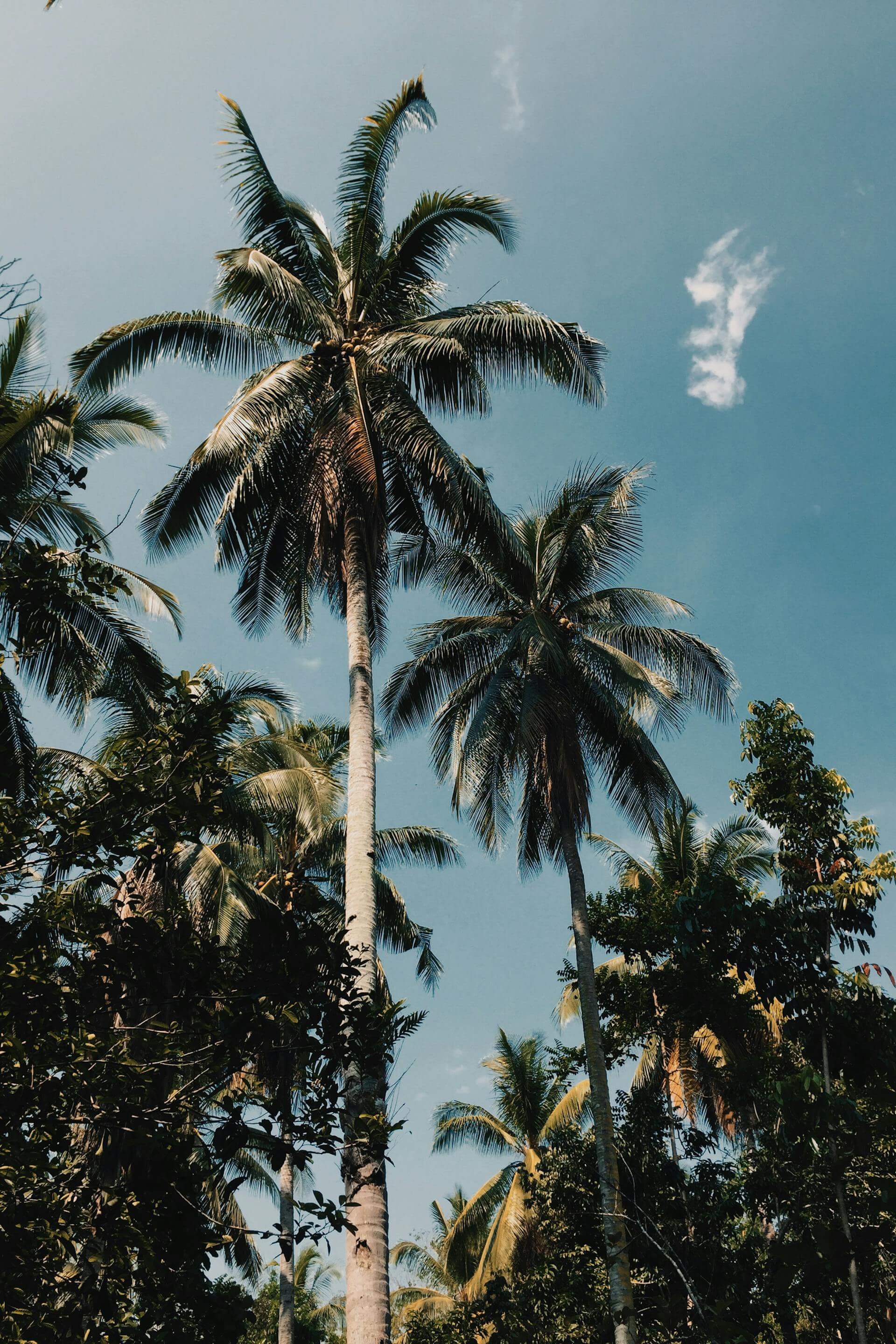
The Highline Trail begins with a move that clarifies things immediately: a narrow ledge cut into the cliff face above the Going-to-the-Sun Road, with a cable anchored to the rock for hikers who need it. The drop below the ledge is several hundred feet. Most people take the cable. The trail then opens into the longest sequence of unobstructed alpine views in the park: the Livingston Range to the west, the peaks above Many Glacier to the east, and the Continental Divide running north as far as you can see into Canada. The Garden Wall, the arrete that forms the spine of the route, was created when two glaciers on opposite sides of the same ridge eroded downward until only a thin fin of rock remained. Running its length in the morning, before the afternoon thunderstorms build over the peaks, is about as close as trail running gets to flying.
The logistics of running in Glacier require planning that most parks do not. The Going-to-the-Sun Road, the 50-mile transmountain road that is the park's main artery, requires a vehicle reservation to enter the Logan Pass area from late May through mid-September. Reservations open months in advance and sell out quickly. The Highline Trail is a point-to-point route; reaching the Granite Park Chalet at the far end requires either a prior camping reservation at the chalet or the return of a park shuttle to the Logan Pass Visitor Center, which runs on a set schedule. None of this is complicated, but all of it needs to happen before you arrive, and arriving without it is how people end up hiking the road shoulder back to their cars at 4 p.m. in afternoon lightning.


Bear encounters on the Highline Trail are not unusual; grizzly sightings are reported regularly throughout the summer season. The NPS recommends carrying bear spray, hiking in groups of three or more, and making noise on the trail, particularly near blind corners and in areas with dense vegetation. A bear encounter in Glacier is not the same as a bear encounter in a campground: these animals are habituated to the backcountry, not to human food, and their behavior is correspondingly different. They are not looking for your lunch. They are looking for whitebark pine nuts, glacier lilies, and ground squirrels, and if you give them adequate warning, they will generally move off the trail and let you pass. Generally. Carry the spray. Know how to use it.
The Grinnell Glacier Trail, accessible from the Many Glacier area on the park's east side, is an alternative route with a different character: an out-and-back of 10.8 miles with 1,600 feet of gain, ending at the turquoise terminus lake of the Grinnell Glacier itself. This is the most direct way to reach one of the park's named glaciers on foot, and what you find when you get there is ice that has been retreating for 170 years. The glacier's surface is dusty with rock flour, crevassed, and smaller every season. Standing at the edge of it, the scale of what is being lost becomes concrete in a way that no data can replicate.

The park's trail season is compressed by snow. At Logan Pass, the Highline Trail typically clears of snow in late June or early July and begins to accumulate again in September. The window of full trail access is roughly ten weeks long, and in that window the park receives the majority of its three million annual visitors. Sunrise on the Highline Trail, before the Logan Pass parking lot has filled and the shuttle lines have formed, belongs to whoever got there first. In Glacier, that means arriving by 6 a.m. at the latest. The light on the Garden Wall at sunrise in July is worth it.
The Many Glacier area, on the park's east side off US-89, offers a less-crowded entry point to the same terrain. The Swiftcurrent Pass Trail climbs 3.6 miles to Swiftcurrent Pass at 7,185 feet, where the view north into the Waterton Lakes corridor is unobstructed for miles. The Iceberg Lake Trail, 9.7 miles round trip, ends at a lake that holds floating ice through July. Both trailheads have smaller parking areas and shorter queues than Logan Pass, and both sit in equally active bear country. Make noise. Carry spray. Look for tracks in the mud near the lakeshores. Running in Glacier requires a particular quality of attention: not fear exactly, but awareness elevated to its proper altitude, which is the same altitude as everything else here. Consider the earned solitude of The Lost Coast: California's Most Remote Run, or the high alpine exposure of Hurricane Ridge: Above the Clouds.
OFFICIAL TRAIL MAPS · GLACIER NATIONAL PARK · NPS
Download official trail maps for the Highline Trail, Grinnell Glacier Trail, and all Glacier National Park routes at the NPS Glacier Maps page. Vehicle reservation information for the Going-to-the-Sun Road Logan Pass corridor is available at nps.gov/glac. Reserve early: reservations for peak season open in the prior spring and sell out within hours.
Bear spray is not optional in Glacier: carry a full canister on your hip and know how to deploy it before you reach the trailhead. A packable wind shell handles the exposed traverses on the Garden Wall, where temperature drops of 30 degrees can happen without warning as clouds move across the Continental Divide. A merino midlayer manages the swing from warm valley approaches to cold alpine ridgelines without the weight of a full insulation layer. A technical running cap with a brim is worth carrying for the sun exposure on the open alpine sections; pack a lightweight beanie for the summit wind. Start early, carry water filtration for the backcountry lakes, and build afternoon buffer time: Glacier's summer thunderstorms develop fast and hit hard above treeline.
The last few miles of the Highline Trail descend through wildflower meadows above Granite Park Chalet, a stone backcountry structure built in 1915 that still operates as a hiker's chalet from mid-July through mid-September. From its porch, the view of the Livingston Range to the west is unimpeded for thirty miles. Below you is the Going-to-the-Sun Road, a thread of asphalt in a landscape that would have no use for it if it weren't there. The bears do not use roads. The marmots do not use roads. The mountain goats that pick their way along the cliff faces above you do not use roads. Glacier is one of the places in North America where the things that lived here before us still live here, on their terms, in their range, without concession. Running through it is a privilege that comes with specific obligations. Show up prepared. Make noise. Leave nothing. Come back.