Mirror Lake Loop
Running Beneath Half Dome on Yosemite's Most Accessible Valley Trail
Half Dome towers above you like a granite sentinel. Tenaya Creek reflects the morning sky. And for five smooth miles, you have one of America's most iconic landscapes all to yourself. This is Mirror Lake Loop, and it just might be the best valley floor run in the entire National Park system.
If you came to Yosemite to run, this is your trail. While other routes in the park demand steep climbs and technical footing, Mirror Lake Loop delivers world-class scenery on terrain that actually lets you move. The first mile follows a paved service road. The rest winds through forest, past granite walls, and along the banks of Tenaya Creek. The elevation gain is negligible. The views are not.
Start early. Really early. The Valley Visitor Shuttle runs from 7am to 10pm year-round, dropping you at Stop #17 right at the trailhead. But if you want the mirror effect that gives this lake its name, you need calm water and soft light. That means dawn. That means beating the crowds. That means having Half Dome's reflection all to yourself while everyone else is still ordering coffee at Curry Village.

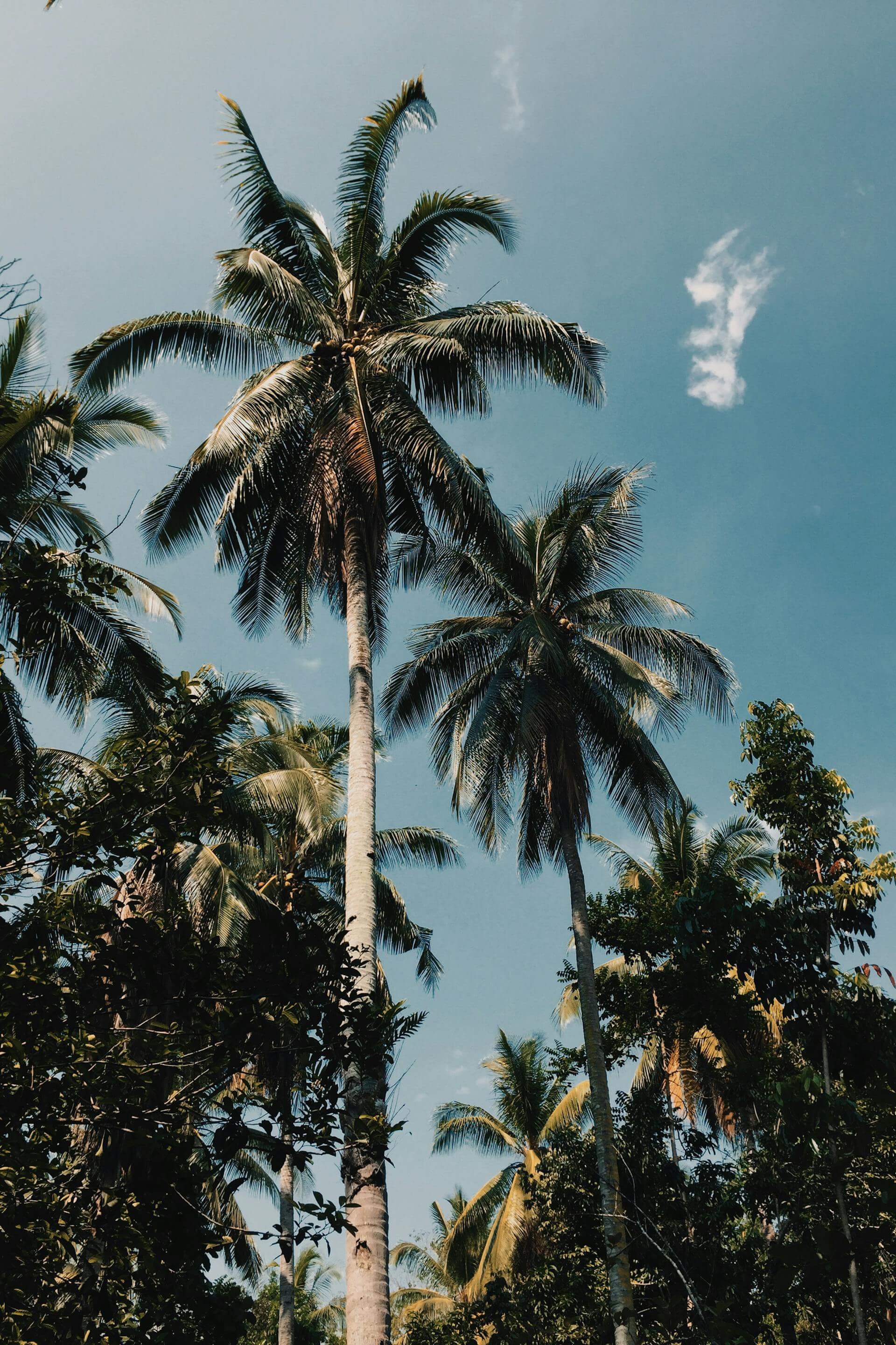
Half Dome rises above Tenaya Canyon, visible for nearly the entire loop
The Route
The loop begins at Shuttle Stop #17 in the eastern end of Yosemite Valley. From here, a paved road leads directly to the lake. This first mile is wide, flat, and fast. Bikes and strollers share the path, so stay aware. But it is also a perfect warmup before the real trail begins.
At the lake, the pavement ends and the loop begins. Head counterclockwise. The north side of the loop offers the best views and the smoothest footing for the first half of your run. You will pass directly beneath Half Dome, closer to its base than almost anywhere else in the park. Washington Column and North Dome frame the canyon ahead. Mount Watkins rises in the distance.
The trail follows Tenaya Creek beyond the lake, crossing two bridges after the Snow Creek Trail junction before looping back on the south side of the canyon. This southern section is shadier, rockier, and slightly more technical. In winter and early spring, it can be icy or flooded. Plan accordingly.
The entire loop covers roughly five miles with minimal climbing. Most runners complete it in 45 minutes to an hour, though you will want to stop for photos. Many times.

The trail follows Tenaya Creek through forest and along granite walls
When to Run
Spring and early summer deliver the full experience. Snowmelt swells Tenaya Creek. The lake fills with water. And when the surface is calm, you get those famous reflections of Half Dome and Mount Watkins. The best mirror effects happen early in the morning before wind stirs the surface.
By late summer, the lake often shrinks to a meadow. Locals call it "Mirror Meadow" during these dry months. The views are still spectacular, but the reflections are gone. The trade-off is fewer crowds and cooler temperatures in the shaded sections.
Winter running is possible but demands preparation. The south side of the loop can stay icy and snow-covered even when the north side is clear. Trail spikes and poles are recommended. Consider running an out-and-back on the north side instead of completing the full loop in snowy conditions.
Trail Essentials
- Location: Yosemite Valley, Shuttle Stop #17
- Distance: 5.0 miles (loop)
- Elevation Gain: Approximately 100 feet
- Difficulty: Easy to Moderate
- Water: None available on trail. Bring your own.
- Restrooms: Vault toilets at lake and near trailhead
- Dogs: Leashed dogs allowed on paved section only
- Hours: Open year-round. Shuttle runs 7am to 10pm.
A Note on Crowds
Mirror Lake is one of Yosemite's most popular destinations. On summer weekends, expect company. The first mile to the lake draws families, photographers, and casual walkers. The loop trail beyond the lake thins out considerably, but you will still encounter hikers moving at a leisurely pace.
The solution is simple: start early. Dawn runs offer solitude, better light, and calmer water for reflections. Weekdays are quieter than weekends. Shoulder seasons offer the best balance of conditions and crowds.

The trailhead at Shuttle Stop #17 marks the start of the loop
The Land and Its People
Long before this became a national park, the Ahwahneechee people made Yosemite Valley their home. Archaeological evidence suggests human presence here stretching back 7,000 to 10,000 years. The Ahwahneechee, whose name means "dwellers in Ahwahnee," developed deep knowledge of this landscape. They managed the valley with controlled burns, protecting oak trees and maintaining the meadows that defined the ecosystem.
Tenaya Creek, which feeds Mirror Lake, carries the name of Chief Tenaya, the last leader of the Ahwahneechee before their forced removal in 1851. When the Mariposa Battalion named the lake after him, Tenaya reportedly protested. "It already has a name," he said. "We call it Py-we-ack, Lake of the Shining Rocks."
Today, the trail passes through land that holds thousands of years of human history. The granite walls witnessed entire civilizations rise and change. The creek still flows. The reflections still appear on calm mornings, just as they did for the Ahwahneechee, just as they will for generations of runners yet to come.
Running Notes
The first mile on pavement is perfect for warming up your legs. Use it. The trail sections beyond the lake feature some rocky patches that demand attention, especially on the south side of the loop. Trail shoes are recommended over road shoes, though the terrain is not technical enough to require aggressive lugs.
Bring water. There is no drinking water available at the trailhead or anywhere on the trail. One liter is sufficient for most runners, but summer heat may warrant more.
Stay on the trail. Tenaya Creek looks shallow and inviting, but the water can become deep and swift quickly. Dangerous whitewater lies just downstream. Do not attempt to cross except at designated bridges.
Safety Note
In 2009, a massive rockfall at Ahwiyah Point sent 115,000 tons of granite crashing 1,800 feet to the valley floor. The impact registered as a magnitude 2.4 earthquake and buried portions of this trail. The trail has been restored, but rockfall remains a real hazard in Yosemite. Stay aware of your surroundings, especially after periods of extreme temperature change.
Getting There
Yosemite National Park charges a $35 entrance fee per vehicle for U.S. residents, valid for seven consecutive days. International visitors should be aware that as of January 2026, a $100 per-person surcharge applies in addition to the standard entrance fee.
Once inside the park, take the free Valley Visitor Shuttle to Stop #17 (Mirror Lake Trailhead). Alternatively, park at Curry Village and add roughly a half-mile walk to reach the trailhead. Private vehicles are not permitted on the road to Mirror Lake unless displaying a disability placard.
Check current road conditions before your visit. Winter weather can close roads or require chains. The park's website and social media channels provide real-time updates.

Mirror Lake Loop trail map showing the full 5-mile route
Gear Up for Yosemite
From crisp valley mornings to warm afternoon miles, layer smart for mountain conditions. Built for the trail. Made like they used to.
Shop Women's PerformanceBeyond the Loop
Mirror Lake Loop works beautifully as a standalone run, but Yosemite Valley offers endless options for those who want more. From the same trailhead, you can connect to the Snow Creek Trail for a steep climb to North Dome. The Valley Loop Trail links to other iconic Yosemite runs including Bridalveil Fall and Yosemite Falls.
For a longer valley floor run, combine Mirror Lake Loop with sections of the bike path that circles the valley. You can easily build a 10 to 15 mile route without ever leaving the valley floor, all while surrounded by granite cliffs, waterfalls, and meadows.

The loop delivers iconic Yosemite views on runnable terrain
The Bottom Line
If you have one morning to run in Yosemite Valley, make it Mirror Lake Loop. The terrain is forgiving. The views are world-class. And the experience of running beneath Half Dome as the first light hits the granite is something that stays with you long after you leave the park.
Start early. Bring water. Stay on the trail. And take your time. The reflections are worth it.
Layer Up for the Valley
Yosemite mornings start cold. Our organic hoodies and performance layers keep you comfortable from the first mile to the finish.
Shop Hoodies & Layers