TRAILHEAD: Running the Interurban Trail

TRAILHEAD: Running the Interurban Trail

The Interurban Trail walkway winding through Pacific Northwest forest in Bellingham, Washington

Rails to Trails: Running the Interurban from Fairhaven to the Sea

A 6.6-mile rails-to-trails adventure through Bellingham's Chuckanut Mountains, where old trolley lines meet waterfalls, island views, and rugged Pacific Northwest coastline.

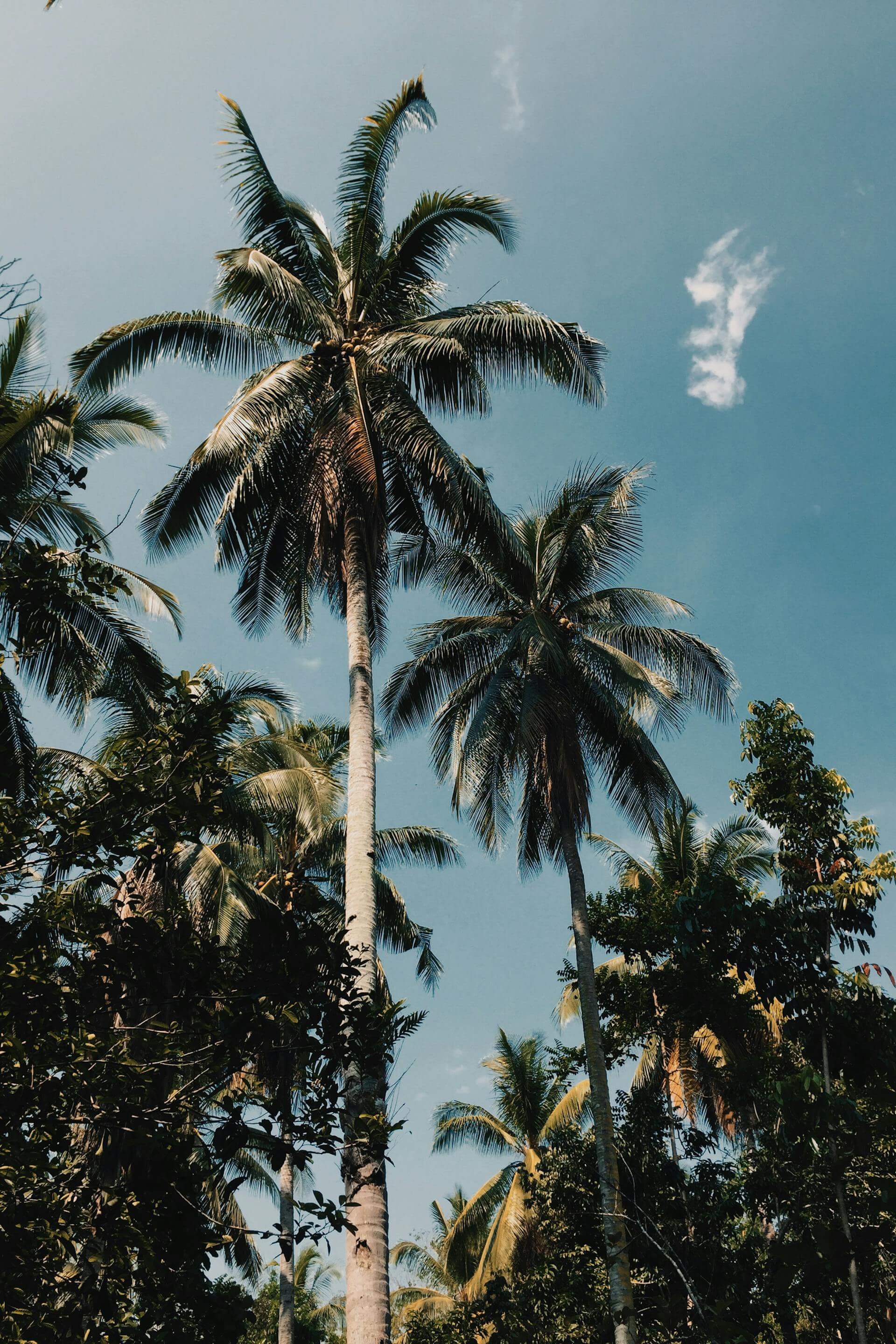
At LLRULE, we chase trails that tell a story. The Interurban Trail in Bellingham, Washington, has been telling its story for over a century, first as an electric trolley line connecting towns, now as one of the Pacific Northwest's most versatile multi-use trails. From Fairhaven to Larrabee State Park, this 6.6-mile route delivers everything: waterfalls, forest, mountain views, and glimpses of the San Juan Islands rising from Chuckanut Bay.

This is the kind of trail that rewards runners, hikers, and adventurers alike. It's long enough to push yourself, varied enough to keep things interesting, and beautiful enough to make you forget you're working. Whether you're looking for a solid training run or an all-day adventure with side trails and beach detours, the Interurban has you covered.

A wooden bridge crossing water along the Interurban Trail in Bellingham

Bridges and boardwalks carry you across creeks and wetlands throughout the trail.

A Trail With History

The Interurban Trail follows the path of an old electric trolley line that once connected Bellingham's neighborhoods to Larrabee State Park and beyond. That trolley stopped running decades ago, but the route it carved through the Chuckanut Mountains remains transformed into a "rails-to-trails" corridor that's become a staple for the local running and hiking community.

There's something satisfying about running a route that once carried commuters and day-trippers. The grade is gentle, only about 300 feet of elevation gain across the entire length, which means you can find a rhythm and hold it. The surface varies from packed gravel to forest floor, with a few sections crossing private gravel roads where residents have authorized trail access. It feels like a trail with purpose, carved into the landscape by people who understood that the journey matters as much as the destination.

"Waterfalls, island views, and coastline,all on one run. The Interurban doesn't make you choose."

The Route: Fairhaven to Larrabee State Park

Most runners start at Fairhaven Park on the north end there's ample parking, and it sets you up for a point-to-point adventure or a solid out-and-back. From there, the trail heads south, passing through Arroyo Park before climbing a set of switchbacks and continuing through the forested Chuckanut Mountains.

About a mile in, you'll hit an optional 0.6-mile side loop that breaks off to Hoag's Ponda quiet, forested pond with a wooden bench that makes for a perfect mid-run pause. Keep going south and you'll enter Arroyo Park, where unmarked side trails tempt you to explore. Stay on the main trail through dense forest, and you'll eventually emerge at Larrabee State Park, Washington's first state park and one of the most beautiful coastal spots in the region.

Run it one way with a shuttle. Run it out-and-back for nearly 12 miles of solid training. Or pick a section and make it your own. The Interurban doesn't demand anything,it just delivers.

A waterfall cascading through lush greenery along the Interurban Trail

Several quaint waterfalls appear along the trail, perfect for a quick photo or moment of stillness.

What You'll See Along the Way

The Interurban Trail is a sensory experience. Dense Pacific Northwest forest gives way to creek crossings and footbridges. Waterfalls appear around corners small but picturesque, cascading through moss-covered rocks. As you move south toward the coast, the forest opens up to reveal sweeping views of Chuckanut Bay and the San Juan Islands in the distance.

Waterfalls

Several small cascades dot the route which are especially beautiful after a rainfall.

Island Views

Glimpses of the San Juan Islands and Chuckanut Bay as you near the coast.

Old-Growth Forest

Sections of dense, moss-draped forest that feel untouched by time.

Coastal Access

Larrabee State Park offers beach access and tide pools at trail's end.

Pacific Northwest beach and coastline near Larrabee State Park at the end of the Interurban Trail

The trail ends at Larrabee State Park where forest meets the rugged Salish Sea coastline.

Multi-Use Means Everyone's Welcome

One of the best things about the Interurban? It's built for everyone. Runners, hikers, mountain bikers, and even equestrians share the trail. Dogs are welcome on leash. You might round a corner and pass a horse and rider, or share a nod with a cyclist heading the opposite direction. It's the kind of trail that brings a community together,and reminds you that the outdoors belong to all of us.

A horse and rider on the Interurban Trail, showcasing the multi-use nature of the path

The Interurban is a multi-use trail—runners share the path with hikers, bikers, and equestrians.

Trail Details

  • Distance: 6.6 miles one way (13.2 miles roundtrip)
  • Elevation Gain: ~300 feet
  • Highest Point: 350 feet
  • Difficulty: Moderate
  • Season: Year-round
  • Trail Use: Hiking, Trail Running, Mountain Biking, Horseback Riding
  • Dogs: Allowed on leash
  • Trailheads: Fairhaven Park, Arroyo Park, Larrabee State Park
  • Features: Waterfalls, coastal views, San Juan Island vistas, forest, beach access

Parking & Passes

Parking at Larrabee State Park requires a Discover Pass,Washington's annual parking pass for state recreation lands. At $30/year (or $10/day), it's one of the best investments you can make if you're running trails across the state.

Fairhaven Park and Arroyo Park trailheads have free parking, making them ideal starting points if you're running point-to-point.

Learn more about Washington trail passes →

Make It Your Own

The beauty of the Interurban is its flexibility. Here are a few ways to run it:

The Full Send (13.2 miles): Start at Fairhaven Park, run to Larrabee State Park, turn around and come back. Solid training day with variety and views.

The Point-to-Point (6.6 miles): Arrange a shuttle or drop a car at Larrabee, then run one way from Fairhaven. Finish at the beach and call it a win.

The Explorer: Start at Arroyo Park, hit the side loop to Hoag's Pond, then continue south as far as you want. Turn around whenever feels right.

The Beach Day: Run to Larrabee, spend some time exploring the tide pools and coastline, then run back. The best kind of destination run.

Gear Up for the Trail

Built for movement. Designed for adventure. Shop performance wear made for runners who go the distance.

Shop Performance

Why We Love It

The Interurban Trail is the kind of route that makes you want to come back. It's accessible enough for beginners but interesting enough for experienced trail runners. The terrain changes. The views evolve. The history beneath your feet reminds you that trails connect us to the land, to the past, and to each other.

If you're in Bellingham,or planning a trip to the Pacific Northwest put the Interurban on your list. Start at Fairhaven, chase the waterfalls, and don't stop until you hit the sea. That's the kind of adventure we live for.

From ski to sea and everything in between. This is the LLRULE way.

Trail Map

Trail map of the Interurban Trail showing the route from Fairhaven to Larrabee State Park

The Interurban Trail connects Fairhaven Park to Larrabee State Park through the Chuckanut Mountains.

Exploration TRAILHEAD

Older Post Newer Post

Leave a comment

TRAILHEAD A Trail Running Series by LLRULE

RSS

Tags

A hiker climbing iron rungs bolted into granite cliff on the Precipice Trail, Acadia National Park, Maine
Acadia Cadillac Mountain Coastal Hiking Maine National Park Precipice Trail Trail Running TRAILHEAD

Acadia: The First Light

TRAILHEAD · ACADIA NATIONAL PARK · MAINE Between early October and early March, the first sunlight to touch United States soil lands on the summit...

Read more
A hiker crosses a suspension bridge on the Wonderland Trail, Mount Rainier National Park, Washington
Hiking Mount Rainier National Park Trail Running TRAILHEAD Volcano Washington Wonderland Trail

Mount Rainier: Ninety-Three Miles Around a Volcano

TRAILHEAD · MOUNT RAINIER NATIONAL PARK · WASHINGTON Mount Rainier is a stratovolcano, which is a useful fact to carry with you on the Wonderland...

Read more
A climber on the Chasm View section of Longs Peak, Rocky Mountain National Park, Colorado
14er Alpine Colorado Hiking Longs Peak National Park Rocky Mountain Trail Running TRAILHEAD

Rocky Mountain: The Air Above Twelve

TRAILHEAD · ROCKY MOUNTAIN NATIONAL PARK · COLORADO The alarm goes off at 2:30 a.m. in Estes Park, and you are already calculating: the trailhead...

Read more
Two backpackers on trail with Grand Teton rising behind them, Grand Teton National Park, Wyoming
Cascade Canyon Grand Teton Hiking National Park Trail Running TRAILHEAD Wilderness Wyoming

Grand Teton: No Foothills, No Warning

TRAILHEAD · GRAND TETON NATIONAL PARK · WYOMING Most mountain ranges give you foothills first. A gradual grade up through lower elevations, through transitional terrain,...

Read more
A person exploring an ice cave in Glacier National Park, Montana
Glacier Highline Trail Hiking Montana National Park Trail Running TRAILHEAD Wilderness

Glacier: Running with Bears

TRAILHEAD · GLACIER NATIONAL PARK · MONTANA You carry bear spray on your hip from the moment you step out of the car at Logan...

Read more
Yosemite: Above the Valley Floor
California Half Dome Hiking National Park Trail Running TRAILHEAD Yosemite

Yosemite: Above the Valley Floor

TRAILHEAD · YOSEMITE NATIONAL PARK · CALIFORNIA The trail up Half Dome begins in shadow. At the Happy Isles trailhead, before dawn has pushed full...

Read more
Hikers descending the South Kaibab Trail, Grand Canyon National Park, Arizona
arizona camping grand canyon national parks rim-to-rim southwest trail running

Grand Canyon: Rim to River to Rim

TRAILHEAD · GRAND CANYON NATIONAL PARK · ARIZONA Every trail run begins with a descent. The Grand Canyon is the only one in America where...

Read more
The Lost Coast: California's Most Remote Run
California Coastal Humboldt TRAILHEAD Wilderness

The Lost Coast: California's Most Remote Run

The highway couldn't follow this stretch of California coast. The terrain was too steep, the cliffs too unstable. So they built the road inland and...

Read more
How to Read a Trail
Craft Skill Trail Running TRAILHEAD Training

How to Read a Trail

Road runners look at where their feet are. Trail runners look at where their feet are going to be. The skill that separates them is...

Read more
Sedona After Sunrise: Red Rock Before the Heat
Arizona Desert Red Rock Sedona TRAILHEAD

Sedona After Sunrise: Red Rock Before the Heat

The red rocks of Sedona hold heat from the day before. Run them at first light, when the temperature is still in the fifties and...

Read more
Malibu Creek: The Santa Monicas' Best Kept Secret
California Los Angeles Malibu Santa Monica Mountains TRAILHEAD

Malibu Creek: The Santa Monicas' Best Kept Secret

Twenty-six miles from the Pacific Coast Highway, Malibu Creek State Park holds 4,000 acres of California chaparral, volcanic rock, creek crossings, and a trail system...

Read more
Columbia River Gorge: Wind, Basalt, and Wildflowers
Columbia River Oregon Pacific Northwest TRAILHEAD Washington Waterfalls

Columbia River Gorge: Wind, Basalt, and Wildflowers

The Columbia River Gorge holds more waterfalls per square mile than anywhere in North America. In spring, the basalt walls run with snowmelt and the...

Read more
Zion Narrows slot canyon
Canyon Desert TRAILHEAD Utah Zion

Zion Narrows: The River Is the Trail

There is no trail through the Zion Narrows. There is only the Virgin River and the canyon walls above it — a thousand feet of...

Read more
Hurricane Ridge alpine trail in Olympic National Park
Alpine Olympic Peninsula Pacific Northwest TRAILHEAD Washington

Hurricane Ridge: Above the Clouds

The Olympic Mountains hold snow until July. The views from Hurricane Ridge reach across the Strait of Juan de Fuca into Canada. This is the...

Read more
Point Reyes coastal trail in morning fog
California Coastal Marin County Point Reyes TRAILHEAD

Point Reyes: Running the Edge of the World

Fog. Elk. A two-hundred-foot cliff above the Pacific. The Bear Valley to Arch Rock corridor is one of the most dramatic trail runs on the...

Read more
Yosemite Sentinel Dome
Exploration TRAILHEAD Yosemite

Yosemite Sentinel Dome

At 8,122 feet, Sentinel Dome delivers one of the most rewarding views in the Sierra Nevada — and only asks two miles from you to...

Read more
Running Yosemites Most Scenic - Mirror Lake Loop
Exploration TRAILHEAD

Running Yosemites Most Scenic - Mirror Lake Loop

Mirror Lake isn't a destination — it's a mirror. Five miles through the floor of Yosemite Valley, with Half Dome doubling itself in still water.

Read more
Chase the Falls: Running Whatcom Falls Park
Exploration TRAILHEAD

Chase the Falls: Running Whatcom Falls Park

The falls are the destination, but the miles getting there are the point. A technical loop through old-growth forest, creek crossings, and stone bridges.

Read more
TRAILHEAD: Stimpson Family Nature Reserve
Exploration TRAILHEAD

TRAILHEAD: Stimpson Family Nature Reserve

A thousand acres of old-growth cedar and fir, ridgelines that open into sky, and a trail system built for those who want to disappear into...

Read more
Ridgeflow™: Where Perseverance Meets Performance
Community Resilience Performance Gear Ridgeflow

Ridgeflow™: Where Perseverance Meets Performance

The Ridgeflow silhouette was built for one purpose: outlast the terrain. Engineered for the runner who doesn't stop when the trail gets hard.

Read more
Joshua Tree: Where Time Bends and Creativity Breaks Open
Exploration TRAILHEAD

Joshua Tree: Where Time Bends and Creativity Breaks Open

In the Mojave, the landscape doesn't just challenge you — it changes you. A run through Joshua Tree is a reckoning with silence, scale, and...

Read more
TERRAIN
TRAILHEAD
THE DRIFT
DISPATCH