Sentinel Dome: Your First Dance with Yosemite Granite
Where the earth curves beneath your feet and the High Sierra spreads like a topographic prayer
Trail Snapshot

Route overview: Sentinel Dome via Glacier Point Road approach
The light hits differently at 8,122 feet. Not the flat, democratic light of the valley floor, but something more selective, more honest. Up here on Sentinel Dome, photons arrive unfiltered through thin air, painting granite in shades that cameras struggle to capture and memory refuses to release.
This is where Yosemite teaches you its first real lesson about verticality.
After the forgiving lap around Mirror Lake, Sentinel Dome asks a different question: Can you climb? Not the lung-searing, quad-burning ascents that wait deeper in your progression, but something more fundamental—a conversation between your stride and the pull of elevation, between flat earth running and the alpine game you're learning to play.
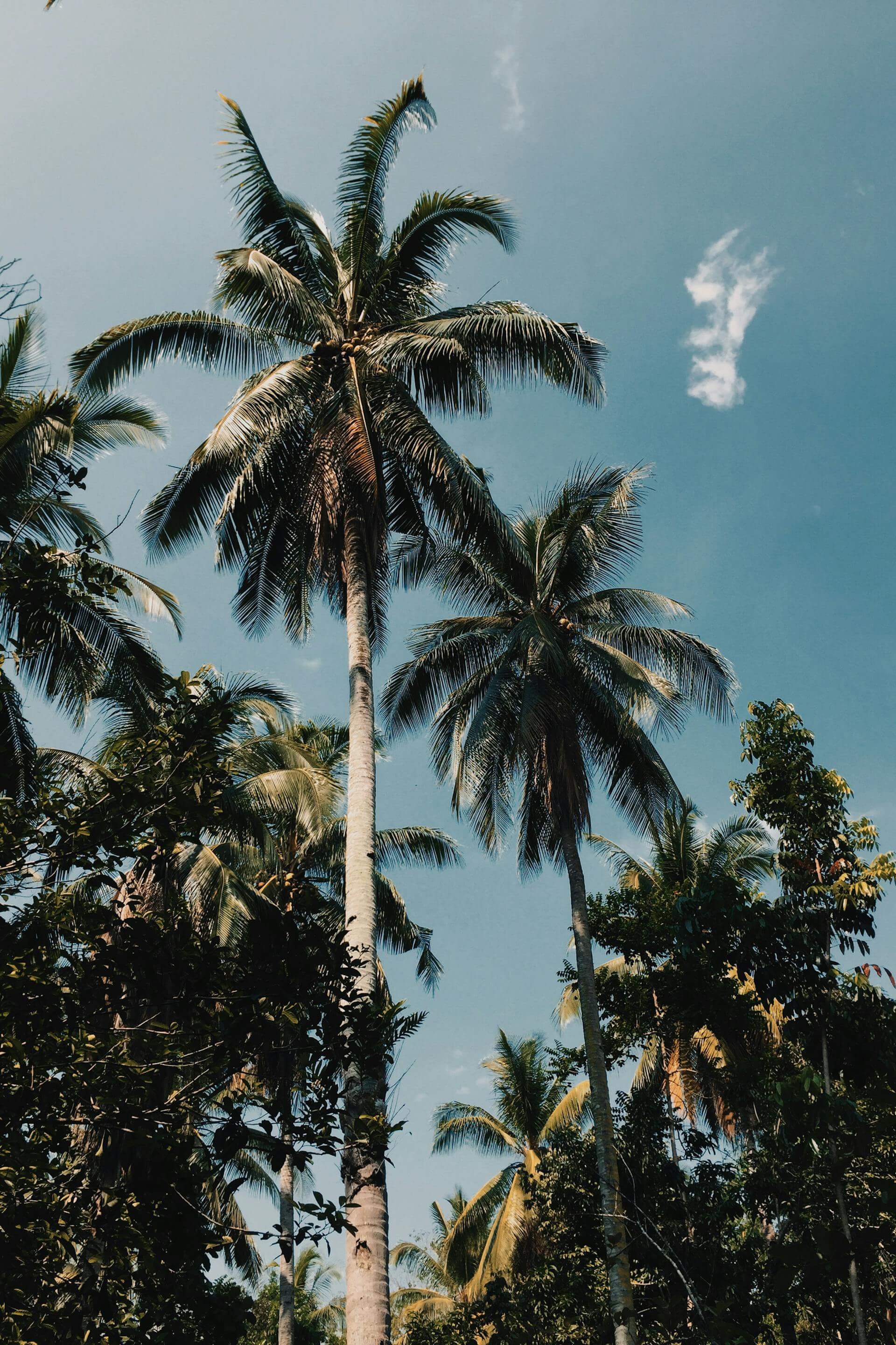
The Approach: Where Forest Becomes Sky
The trail begins with humility. From the Sentinel Dome/Taft Point trailhead along Glacier Point Road, you drop into a mixed conifer forest that smells of Jeffrey pine vanilla and mountain air. The first quarter-mile descends gently—a metabolic warm-up that seems almost generous until you remember: everything you drop, you'll climb back out.

The approach: Where anticipation builds beneath red fir canopy
This is strategic terrain. The trail follows an old fire road for the first mile—wide, smooth, runnable even as it begins its modest climb. Your cardiovascular system calibrates to 8,000 feet. Your stride finds its alpine rhythm. You're not racing here; you're learning to move efficiently where oxygen becomes a negotiable commodity.
Watch for the junction at 0.6 miles. The trail splits: Taft Point left (save that for later), Sentinel Dome right. You veer onto singletrack, and the forest begins its retreat. Red fir gives way to western white pine. The understory thins. Light sharpens. The dome materializes through the trees like a granite prophecy.
The Ascent: Granite's Gentle Introduction
Here's where Sentinel earns its "easy-moderate" rating. The final approach to the summit isn't technical by Yosemite standards—no cables, no exposure, no death-defying scrambles. But it is granite, and granite has rules.
⚠️ Surface Transition Alert
The last 0.2 miles transitions from dirt trail to slickrock. Your tread matters here. Aggressive lugs find purchase on the textured granite. Road-running shoes will slip on smooth sections, especially if conditions are wet or dusty. This is your introduction to technical footwork—short, deliberate steps, weight centered over your feet, eyes scanning two steps ahead for the friction zones.
The dome rises in stages, each one steeper than the last. You power-hike when the grade demands it—no shame in that. Elite mountain runners walk steep terrain all the time; it's metabolically more efficient than trying to maintain a grinding shuffle. What matters is maintaining forward momentum, keeping your breathing controlled, feeling your calves and glutes do the work they were designed for.
And then, suddenly: sky.
The Summit: 360 Degrees of Consequence

The payoff: Half Dome, Yosemite Falls, and the High Sierra unfold in every direction
The summit of Sentinel Dome isn't a point—it's a platform. A gently rounded cap of granite approximately 100 yards across, barren except for the skeletal remains of a Jeffrey pine that died in 2003 after 400-plus years of improbable survival. That tree is your landmark, your photo op, your meditation point.
But the real show is the view.
North: Half Dome rises like a granite fist, its northwest face throwing afternoon shadow across Tenaya Canyon. On clear days you can trace the cable route with binoculars, watch ant-sized climbers navigate the final 400 feet.
East: The Clark Range serrates the horizon, snow-clad even in summer. Closer in, the Merced River corridor cuts through forest like a green vein.
South: The Valley spreads beneath you—El Capitan's monolithic west face, Cathedral Rocks' spires, Bridalveil Fall's ephemeral mist.
West: Yosemite Falls drops 2,425 feet in three tiers, its roar audible from here when snowmelt is heavy. The falls peak in May, fade to a whisper by August, disappear entirely in drought years.

The High Sierra spreads like a topographic encyclopedia—every ridge a chapter, every canyon a verse
The Runner's Experience: What This Trail Teaches
Sentinel Dome is perfectly positioned as your second trail in the Yosemite progression. After Mirror Lake's flat, forgiving loop, this route introduces four critical skills:
1. Climbing Efficiency
The 390-foot gain is modest—about 170 feet per mile—but it's enough to teach your body to process lactate while ascending. You'll learn the difference between "pushing through" and "pacing through." The former leads to bonking on longer climbs. The latter leads to summits.
Focus on breathing rhythm. Match inhale-exhale patterns to your stride. Many runners find a 3:3 pattern works well at altitude: three steps breathing in, three steps breathing out. Experiment. Find your cadence.
2. Technical Footing
The granite approach is Yosemite in miniature—rough enough to grip, smooth enough to punish inattention. You're learning to read rock texture, to distinguish friction slabs from polished zones, to shift weight deliberately rather than reactively.
This skillset scales. The scrambling required here is gentle preparation for the granite staircases on Mist Trail, the slickrock sections on Upper Yosemite Falls, the cable approach on Half Dome.
3. Altitude Adaptation
At 8,122 feet, Sentinel Dome sits roughly 4,000 feet above the valley floor. Oxygen availability drops by about 25% compared to sea level. Your body responds by breathing faster, your heart by beating harder. This is normal. This is adaptation.
Pay attention to how you feel. Mild headache? Slight nausea? Unusual fatigue? These are early altitude indicators. Not dangerous at this elevation, but worth noting. If symptoms worsen, descend. The mountain will be here tomorrow.
4. Descent Control
What goes up must come down—and downhill running on granite requires a different biomechanical approach than dirt. Shorter strides, higher cadence, weight centered over your feet rather than leaning back. Let your quads do eccentric work (lengthening under load), but don't let them bear the full braking load. That's how you torch them for the next day's run.
The fire road descent back to the trailhead is where you can open up your stride, let gravity assist, feel the joy of downhill flow. But stay controlled. Rolled ankles end trips.
🏃 Runner's Beta: Essential Intelligence
- Timing: Early morning is prime—cool temps, soft light, fewer crowds. Summit at sunrise for alpenglow on Half Dome. Afternoon thunderstorms are common July-September; be off the exposed dome by 2pm.
- Water: Carry at least 16oz. There's no water on trail. The short distance tempts people to skip hydration—don't. Altitude + exertion + sun exposure = dehydration happens faster than you think.
- Footwear: Trail runners with aggressive tread. The Altra Lone Peak, Hoka Speedgoat, and Salomon Speedcross series all excel here. Avoid road shoes—you'll slip on the granite approach.
- Layer Strategy: Start cool. The climb warms you fast. Pack a windbreaker for the summit—exposed granite + elevation + wind = surprising chill even on hot days. In spring/fall, bring a light insulation layer.
- Season Timing: Glacier Point Road typically opens late May (snow-dependent) and closes with first significant snowfall (usually November). Call Yosemite Road Conditions: (209) 372-0200 for current status.
- Photography: The summit demands lens time. Bring your phone or camera. The dead Jeffrey pine in golden hour light is iconic. Half Dome at sunset is transcendent. Budget 20-30 minutes up top to fully experience the view.
- Turnaround Options: Not feeling it on the climb? The trail junction at 0.6 miles makes a natural turnaround. You'll still get 1.2 miles with 200 feet of climbing—a solid introductory effort without the commitment to the summit.
Putting Sentinel in Context
This is where your Yosemite running education advances from "flat and scenic" to "vertical with consequence." Mirror Lake taught you the valley's rhythms. Sentinel Dome teaches you its dimensions.
The vertical gain here—390 feet—is exactly double what you'll encounter on Mirror Lake (if you add the loop extensions). It's a pedagogical bridge. Enough to challenge without overwhelming. Enough to prepare you for the bigger climbs ahead: Mist Trail's 1,000 feet, Upper Yosemite Falls' 2,700 feet, Half Dome's 4,800 feet.
But more than the physical preparation, Sentinel Dome shifts your relationship with the landscape. On Mirror Lake, you were in Yosemite. On Sentinel Dome, you're above it. You see the valley not as a corridor but as a three-dimensional sculpture—reading contours, tracing drainages, understanding how water and ice carved this cathedral over millions of years.
This perspective matters. Because mountain running isn't just about moving through terrain—it's about understanding terrain. About developing what climbers call "mountain sense." About knowing when to push, when to back off, when to simply stop and witness.
The Descent: Taking It With You
The return trip is almost meditative. You retrace your steps across the granite dome, careful on the initial smooth sections. The trail reclaims you at the tree line. You flow down the fire road, legs loose, breathing easy, endorphins flooding your system with that particular satisfaction that only comes from voluntary suffering rewarded with involuntary awe.
Back at the trailhead, you stretch against your car, gulp water, feel the pleasant fatigue settling into your muscles. You're 2.3 miles stronger. 390 feet higher in your progression. One summit closer to understanding what this place can teach you about resilience, patience, and the quiet joy of upward motion.
Sentinel Dome isn't Yosemite's hardest run. It's not even close. But it might be its most generous—offering a manageable challenge wrapped in immoderate beauty, demanding just enough effort to feel earned, rewarding you with views that professionals spend entire careers trying to capture.
This is your gateway to granite. Use it well.
📍 What's Next in Your Progression?
Trail #3: Mist Trail to Vernal Fall awaits. Now that you've learned to climb gradually on fire roads and navigate gentle granite, you're ready for Yosemite's most iconic technical ascent: 600+ granite stairs carved into cliffsides, waterfalls thundering beside you, elevation gained in concentrated bursts rather than steady grades. It's the next logical step in your vertical education. Distance is similar (5 miles), but intensity jumps significantly. You've been warned. You've been prepared. The mist is calling.