Hikers descending the South Kaibab Trail, Grand Canyon National Park, Arizona

Grand Canyon: Rim to River to Rim

TRAILHEAD · GRAND CANYON NATIONAL PARK · ARIZONA

NPS | Jagged limestone pillars frame sunset-lit peaks deep inside the Grand Canyon, Arizona

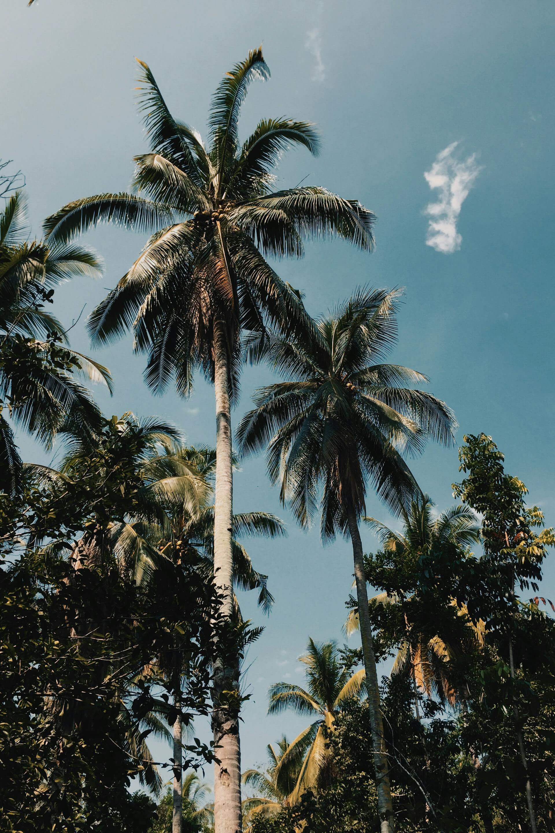
Every trail run begins with a descent. The Grand Canyon is the only one in America where the descent is the easy part. The South Kaibab Trail drops 4,780 feet from the South Rim to the Colorado River in 6.9 miles, through limestone, shale, sandstone, and finally the dark Vishnu schist at the bottom: rock that is 1.84 billion years old, among the oldest exposed stone on Earth. You are running through geologic time, layer by layer, and the canyon keeps opening below you in ways that photographs cannot prepare you for.

What makes the Grand Canyon different from every other trail in this series is the arithmetic of return. The NPS does not recommend running rim-to-river-to-rim in a single day, and they are right not to. The descent takes 90 minutes at a steady run. The ascent on Bright Angel Trail takes four to five hours at a hard effort in October. In July, in the inner canyon, the air temperature at noon runs past 110 degrees Fahrenheit. People die here every year from heat and dehydration. The canyon is not trying to kill you. It simply does not care whether you are prepared.

Distance21 mi R2R
Elevation Gain5,740 ft
DifficultyStrenuous
SurfaceLimestone / Shale / Granite
Two backpackers descending the South Kaibab Trail, Grand Canyon National Park — NPS Photo/V. Allen

The standard rim-to-rim route runs South Kaibab down and Bright Angel up, or in reverse if you are starting from the North Rim. The South Kaibab has no water and no shade: you carry everything you need from the trailhead. Bright Angel has water stations at Indian Garden (now called Havasupai Gardens, at mile 4.6) and at the 3-mile resthouse, which matters a great deal on the way up. The two trails together cover 21 miles and 5,740 feet of total gain. Most people doing this as a single day run cache a bag at Phantom Ranch the night before, sleep inside the canyon, and run the ascent in the cool of the pre-dawn. The logistics are part of the experience.

Phantom Ranch sits at 2,480 feet elevation on the north bank of the Colorado. It is the only lodging inside the Grand Canyon and it is booked through a lottery that opens 15 months in advance. Most lottery entrants do not win on the first try. Bright Angel Campground, adjacent to the Ranch, takes backcountry permits through the NPS permit system and is more accessible. The sound of the Colorado at night, running fast over its boulders, is unlike any other camp sound in the American West. The canyon walls rise 4,000 feet above you in every direction.

“You are running through geologic time, layer by layer, and the canyon keeps opening below you in ways that photographs cannot prepare you for.”
Two backpackers rounding a switchback on the South Kaibab Trail — NPS Photo/M. Quinn Day hikers ascending the Bright Angel Trail near the tunnels, Grand Canyon — NPS Photo/Michael Quinn

October is when the Grand Canyon gives you everything it has. The South Rim sits at 6,860 feet and runs cool: mornings in the low 40s, afternoons in the mid-60s. The inner canyon stays warm enough to run in a single layer. The crowds that define summer are gone. The cottonwood trees along Bright Angel Creek turn gold at the canyon bottom, and the light that hits the Redwall Limestone in the afternoon turns the whole inner canyon the color of old iron. The geology also tells a clearer story in October: the shadows define the strata, and you can read the layers the way you learn to read a river in fly fishing, each band its own era, each color a different ocean floor or desert that once existed here. The connection between geology and moving water runs both ways: the Colorado is also a threatened river, its flow reduced by decades of upstream diversion, its temperature shifting in ways that affect the canyon ecosystem from the bottom up.

There is a detail on the South Kaibab that most rim visitors miss entirely. At Cedar Ridge, 1.5 miles from the South Rim trailhead, the trail reaches a broad saddle with unobstructed views in every direction. Most day hikers stop here. Trail runners pass through it in 18 minutes and keep going into terrain that fewer people see each year than visit the Louvre in a day. Below Cedar Ridge the canyon narrows, the walls grow steeper, and the scale shifts into something the human eye does not have a good reference point for. The inner gorge walls are vertical for 1,500 feet. The river is a green thread at the bottom. The bridge is smaller than it should be.

NPS | A hiker with a backpack climbs uphill on a backcountry trail in the Grand Canyon, Arizona

The North Rim is a different canyon than the South. It sits 1,000 feet higher, receives twice the precipitation, and supports stands of aspen and mixed conifer that make the approach feel entirely unlike the arid ponderosa plateau of the southern approach. The North Rim is open May 15 through October 15 and closes for winter when the road becomes impassable. Running in from the North on the North Kaibab Trail means 14 miles to Phantom Ranch with 5,760 feet of descent through a series of gorges, each one a canyon within the canyon: Roaring Springs Canyon, Manzanita Canyon, the Box. The North Kaibab is the more remote trail and the more dramatic approach. The river-to-river-to-river logic of the route, each side a different landscape, each ascent a different test, is what gives rim-to-rim its reputation for being the canyon's true measure.

Mule strings have right-of-way on all Grand Canyon trails. When you hear them coming, step to the uphill side of the trail and stand still. This is not a suggestion. The mules carry supplies to Phantom Ranch and their handlers have been managing this trail longer than most runners have been alive. Running past a mule at speed is how people get thrown off a trail with a 1,000-foot drop on one side. The skills that matter on technical trail matter even more here: knowing when to yield, when to slow, when the surface underfoot is telling you something.

NPS | Four people in a wooden dory running a rapid on the Colorado River through the Grand Canyon NPS | Last warm light of sunset falling on the peaks and canyon walls of the Grand Canyon, Arizona NPS | Two visitors at a Grand Canyon overlook watching a rare cloud inversion fill the canyon below, Arizona

OFFICIAL TRAIL MAP · GRAND CANYON NATIONAL PARK · NATIONAL PARK SERVICE

Source: National Park Service — Grand Canyon National Park

Pack Right

The South Kaibab has no water. Carry two liters minimum from the rim and plan your descent around that. A merino base layer handles the rim cold at 5am and the inner canyon warmth by 9am without requiring a gear swap. A lightweight shell compresses to nothing and stays in the pack below the rim. Electrolytes matter more than food on the ascent: the climb out on Bright Angel is where cramping ends trips, not the descent. Start before sunrise. Be at the river by 8am. Be off the trail before noon in any month other than October through April.

You will know when you get back to the rim. Not because the trail ends, but because the sound changes. The wind that was canyon-filtered and particular becomes open-sky wind. The trees come back. The pavement appears. And below you, behind you, is the thing you ran through: two billion years of Earth, one river, a route that measures you against something indifferent and enormous and worth every step of the return.

arizona camping grand canyon national parks rim-to-rim southwest trail running

Older Post Newer Post

Leave a comment

TRAILHEAD A Trail Running Series by LLRULE

RSS

Tags

A hiker climbing iron rungs bolted into granite cliff on the Precipice Trail, Acadia National Park, Maine
Acadia Cadillac Mountain Coastal Hiking Maine National Park Precipice Trail Trail Running TRAILHEAD

Acadia: The First Light

TRAILHEAD · ACADIA NATIONAL PARK · MAINE Between early October and early March, the first sunlight to touch United States soil lands on the summit...

Read more
A hiker crosses a suspension bridge on the Wonderland Trail, Mount Rainier National Park, Washington
Hiking Mount Rainier National Park Trail Running TRAILHEAD Volcano Washington Wonderland Trail

Mount Rainier: Ninety-Three Miles Around a Volcano

TRAILHEAD · MOUNT RAINIER NATIONAL PARK · WASHINGTON Mount Rainier is a stratovolcano, which is a useful fact to carry with you on the Wonderland...

Read more
A climber on the Chasm View section of Longs Peak, Rocky Mountain National Park, Colorado
14er Alpine Colorado Hiking Longs Peak National Park Rocky Mountain Trail Running TRAILHEAD

Rocky Mountain: The Air Above Twelve

TRAILHEAD · ROCKY MOUNTAIN NATIONAL PARK · COLORADO The alarm goes off at 2:30 a.m. in Estes Park, and you are already calculating: the trailhead...

Read more
Two backpackers on trail with Grand Teton rising behind them, Grand Teton National Park, Wyoming
Cascade Canyon Grand Teton Hiking National Park Trail Running TRAILHEAD Wilderness Wyoming

Grand Teton: No Foothills, No Warning

TRAILHEAD · GRAND TETON NATIONAL PARK · WYOMING Most mountain ranges give you foothills first. A gradual grade up through lower elevations, through transitional terrain,...

Read more
A person exploring an ice cave in Glacier National Park, Montana
Glacier Highline Trail Hiking Montana National Park Trail Running TRAILHEAD Wilderness

Glacier: Running with Bears

TRAILHEAD · GLACIER NATIONAL PARK · MONTANA You carry bear spray on your hip from the moment you step out of the car at Logan...

Read more
Yosemite: Above the Valley Floor
California Half Dome Hiking National Park Trail Running TRAILHEAD Yosemite

Yosemite: Above the Valley Floor

TRAILHEAD · YOSEMITE NATIONAL PARK · CALIFORNIA The trail up Half Dome begins in shadow. At the Happy Isles trailhead, before dawn has pushed full...

Read more
The Lost Coast: California's Most Remote Run
California Coastal Humboldt TRAILHEAD Wilderness

The Lost Coast: California's Most Remote Run

The highway couldn't follow this stretch of California coast. The terrain was too steep, the cliffs too unstable. So they built the road inland and...

Read more
How to Read a Trail
Craft Skill Trail Running TRAILHEAD Training

How to Read a Trail

Road runners look at where their feet are. Trail runners look at where their feet are going to be. The skill that separates them is...

Read more
Sedona After Sunrise: Red Rock Before the Heat
Arizona Desert Red Rock Sedona TRAILHEAD

Sedona After Sunrise: Red Rock Before the Heat

The red rocks of Sedona hold heat from the day before. Run them at first light, when the temperature is still in the fifties and...

Read more
Malibu Creek: The Santa Monicas' Best Kept Secret
California Los Angeles Malibu Santa Monica Mountains TRAILHEAD

Malibu Creek: The Santa Monicas' Best Kept Secret

Twenty-six miles from the Pacific Coast Highway, Malibu Creek State Park holds 4,000 acres of California chaparral, volcanic rock, creek crossings, and a trail system...

Read more
Columbia River Gorge: Wind, Basalt, and Wildflowers
Columbia River Oregon Pacific Northwest TRAILHEAD Washington Waterfalls

Columbia River Gorge: Wind, Basalt, and Wildflowers

The Columbia River Gorge holds more waterfalls per square mile than anywhere in North America. In spring, the basalt walls run with snowmelt and the...

Read more
Zion Narrows slot canyon
Canyon Desert TRAILHEAD Utah Zion

Zion Narrows: The River Is the Trail

There is no trail through the Zion Narrows. There is only the Virgin River and the canyon walls above it — a thousand feet of...

Read more
Hurricane Ridge alpine trail in Olympic National Park
Alpine Olympic Peninsula Pacific Northwest TRAILHEAD Washington

Hurricane Ridge: Above the Clouds

The Olympic Mountains hold snow until July. The views from Hurricane Ridge reach across the Strait of Juan de Fuca into Canada. This is the...

Read more
Point Reyes coastal trail in morning fog
California Coastal Marin County Point Reyes TRAILHEAD

Point Reyes: Running the Edge of the World

Fog. Elk. A two-hundred-foot cliff above the Pacific. The Bear Valley to Arch Rock corridor is one of the most dramatic trail runs on the...

Read more
Yosemite Sentinel Dome
Exploration TRAILHEAD Yosemite

Yosemite Sentinel Dome

At 8,122 feet, Sentinel Dome delivers one of the most rewarding views in the Sierra Nevada — and only asks two miles from you to...

Read more
Running Yosemites Most Scenic - Mirror Lake Loop
Exploration TRAILHEAD

Running Yosemites Most Scenic - Mirror Lake Loop

Mirror Lake isn't a destination — it's a mirror. Five miles through the floor of Yosemite Valley, with Half Dome doubling itself in still water.

Read more
Chase the Falls: Running Whatcom Falls Park
Exploration TRAILHEAD

Chase the Falls: Running Whatcom Falls Park

The falls are the destination, but the miles getting there are the point. A technical loop through old-growth forest, creek crossings, and stone bridges.

Read more
TRAILHEAD: Running the Interurban Trail
Exploration TRAILHEAD

TRAILHEAD: Running the Interurban Trail

Sixteen miles of converted rail corridor through Bellingham, Washington. A case for the urban trail as a form of moving meditation.

Read more
TRAILHEAD: Stimpson Family Nature Reserve
Exploration TRAILHEAD

TRAILHEAD: Stimpson Family Nature Reserve

A thousand acres of old-growth cedar and fir, ridgelines that open into sky, and a trail system built for those who want to disappear into...

Read more
Ridgeflow™: Where Perseverance Meets Performance
Community Resilience Performance Gear Ridgeflow

Ridgeflow™: Where Perseverance Meets Performance

The Ridgeflow silhouette was built for one purpose: outlast the terrain. Engineered for the runner who doesn't stop when the trail gets hard.

Read more
Joshua Tree: Where Time Bends and Creativity Breaks Open
Exploration TRAILHEAD

Joshua Tree: Where Time Bends and Creativity Breaks Open

In the Mojave, the landscape doesn't just challenge you — it changes you. A run through Joshua Tree is a reckoning with silence, scale, and...

Read more
TERRAIN
TRAILHEAD
THE DRIFT
DISPATCH